There is nothing fun about getting lost while hiking or backpacking. Imagine being in the middle of nowhere with no idea how to get back to safety.
I live in the south of Tasmania which has some of the most amazing hiking and backpacking trails in the world. In 2019 alone, the Westpac Rescue Helicopter made 44 bushwalker rescues across Tasmania. The number of people that get lost in the bush throughout Australia must be staggering.
If you’re planning on walking off the beaten track you need to invest in some form of a map. A handheld GPS gives you an extra layer of peace of mind to get you where you need to go.
My first GPS was a Garmin eTrex which was very basic in terms of its functionality at the time. Garmin is still a leader in GPS navigation technology although the functionality of the units has improved out of sight.
Many hikers, bushwalkers, and backpackers will not leave home without their handheld GPS. When used together with a compass and a map, you’ll never get lost again.
Can’t wait to get out there and start hiking up that mountain? Click here to see my recommended best handheld GPS
Tip: If you need help, then we recommend skipping ahead to our guide which lists important things to consider when purchasing a handheld GPS unit.
Best Handheld GPS Australia 2023 Comparison Guide
This is a comparison chart to help you choose the best handheld GPS for your needs. Use this table to compare the features of the various handhelds on the market and if you would like more information or check the current price, click on the name of the product.
Durable
Compact
USB-C Cable not included
Weight: 156g
Water-resistant
Good size internal memory 8GB
Joystick can be tricky to operate
Weight: 142g
Preloaded maps for Australia
Additional GNSS Support
No touch screen
Weight: 217g
GPS, GLONASS & GALILEO satellites
Long life lithium-ion battery
Weight: 397g

2-way messaging
Large buttons
Bulky
Weight: 230g
Best Handheld GPS Reviews Australia 2023
Garmin eTrex SE Handheld GPS Review

Our Verdict:
The Garmin eTrex SE Handheld GPS is a reliable and versatile navigation device, perfect for outdoor enthusiasts seeking freedom and adventure. With its 2.2′ high-resolution display, long battery life, and multi-GNSS support, this GPS navigator offers accurate tracking in challenging environments.
Its water-resistant design and digital compass provide durability and precise heading information. The device can also be paired with the Garmin Explore App for wireless updates and trip planning.
The performance and accuracy of the Garmin eTrex SE Handheld GPS has been praised by customers, with positive feedback on its ability to track in challenging environments and provide accurate heading information.
Whether you’re hiking in the wilderness or exploring new territories, the eTrex SE ensures that you have the freedom to explore with confidence, knowing that you’ll always have accurate location and direction information at your fingertips.
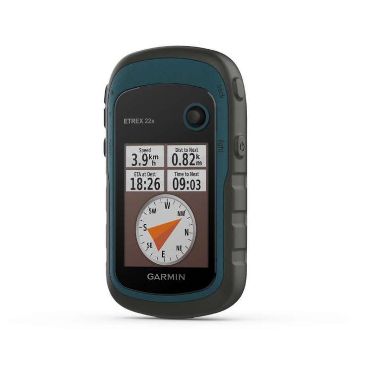
Garmin eTrex 22X Handheld GPS Review
Our Verdict:
The Garmin eTrex 22X is the new and improved version of the popular eTrex 20 and 20x models, featuring upgraded screen resolution and loads more memory. It is designed to be easy to use, yet durable and compact.
One of the standout features of the eTrex 22x is the long battery life, powered by two AA batteries which can operate for up to 25 hours. Using a common battery type means you can always carry an extra set in case of emergencies.
Despite being one of the best performing entry-level handheld receivers on the market, the eTrex 22x is also very compact and lightweight. The physical dimensions of the unit are 5.4 x 10.3 x 3.3cm and it weighs only 142 grams with batteries. This is an ideal size and weight for storing away in your pocket or backpack when you’re on the move.
The eTrex 22x is preloaded with TopoActive maps and also supports the download of Garmin Birdseye Satellite Imagery (subscription required), allowing you to download an unlimited amount of background aerial imagery.
So if you’re looking for an affordable handheld GPS with a tough exterior and a few bells and whistles, the eTrex 22x is a solid choice. It’s a great unit for the occasional hiker who is not interested in large touch screens but enjoys the portable robust performance.
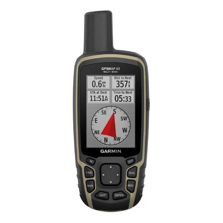
Garmin GPSMAP 65 Handheld GPS Review
Our Verdict:
If you’re looking for a handheld GPS with a decent sized colour screen and better reception, the Garmin GPSMAP 65 is a great hiking companion.
This unit features a 2.6″ sunlight-readable colour screen which to view your chosen topographic map background imagery. The GPSMAP 65 supports the use of BirdsEye Satellite Imagery (additional subscription required) to enable the loading of high-quality satellite images onto the unit.
The GPSMAP 65 has also been upgraded to include additional satellite constellations to allow you to obtain your position in quick time and keep your fix with the quad helix high-sensitivity antenna. The unit is capable of receiving GPS, GLONASS, Galileo, QZSS and IRNSS signals, dramatically improving the number of available satellites.
Garmin offers various options in the GPSMAP 65 series with one of the feature-packed models being the GPSMAP 65s which includes a barometer, altimeter and compass.
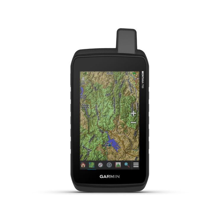
Garmin Montana 700 Rugged Handheld GPS Review
Our Verdict:
The Garmin Montana 700 Rugged Handheld GPS is an impressive unit with hugh durability and long battery life. As someone who values freedom and adventure, having a reliable GPS is crucial for exploring the great outdoors.
The Montana 700 Rugged is built to withstand tough conditions, meeting the MIL-STD 810 standards for thermal, shock, water, and vibration. Whether your hiking through rugged terrain or facing unpredictable weather, you can trust that this device will hold up.
The 18+ hours of battery life in GPS mode is a game-changer. You don’t have to worry about the GPS dying in the middle of a journey, allowing you to stay focused on the adventure ahead. The touchscreen feature makes it easy to navigate through maps and access information quickly.
Overall, the Garmin Montana 700 Rugged Handheld GPS is a reliable and durable companion for any outdoor enthusiast. It provides the freedom to explore without the fear of getting lost or running out of battery.
Garmin GPSMAP 66i Handheld GPS Review

Our Verdict:
Stop your family worrying about you, stay in touch with the Garmin GPSMAP 66i. The standout feature of this unit is its ability to communicate via text messages when mobile communication signals are not available. This allows you to not only keep friends and relatives updated about the safety of the walking party but also to communicate with emergency services in a rescue situation.
The SOS button allows you to not only send a distress message but also to stay in touch with critical information about the rescue. When the SOS function is activated the unit also sends regular position updates to emergency responders. Importantly, the SOS call can be cancelled if circumstances change.
The one downside about the awesome text and SOS functionality is that a Garmin Satelite Subscription is required to access these and other features, including weather updates, and location sharing. Garmin currently offers month to month subscriptions, so if you only intend on using the unit occasionally, you can suspend the service when you don’t need it.
One area where GPSMAP 66i is a step up from other models is that the unit comes with the ability to download BirdsEye Satellite Imagery without needing an ongoing subscription. It’s important to note that you will need to transfer the imagery from your computer to the unit before heading out in the field.
What is a handheld GPS and why do you need one?
A handheld GPS unit is a portable spatial measurement device used to record 2D and 3D positions by continuously measuring satellites orbiting the earth.
If you’re planning on taking a hike or bush walk in Australia, a handheld GPS is very helpful in the following ways:
- Having the ability to pinpoint your location without the need for phone reception is a huge advantage. You’ll never have to say where the bloody hell am I again!
- Some advanced models have the ability to send two-way messages and satellite communication so you should never need to send for emergency assistance if you find yourself lost in the bush.
- You are able to track all of your movements in the field by storing points and tracks to monitor your progress and share your adventures with friends and family.
Common GPS acronyms to get your head around
As you are researching handheld GPS units, there are a ton of acronyms and jargon to understand. Here’s a handy list to get you started:
GPS Global Positioning System. United States satellite system.
Galileo Europe’s satellite system.
GLONASS Russia’s satellite system. Many of the latest models support both GPS and GLONASS satellite tracking for faster and more reliable positioning.
GNSS Global Navigation Satellite System. This term is used to collectively describe all satellite positioning constellations.
IRNSS Indian Regional Navigation Satellite System. A seven satellite regional navigation system developed by India.
QZSS Quasi-Zenith Satellite System. A four satellite regional satellite system developed by Japan.
SBAS Satellie-Based Augmentation System. A regional network of ground and satellite systems that boost the accuracy of GPS and GNSS signals.
Topographic Map A detailed map that illustrated points of interest of both natural and man-made features, including elevations and contour lines.
Waypoint A point of reference at a specific location. Waypoints can be recorded with the GPS or uploaded to navigate to.
Features of Top Rated Handheld GPS Devices
The features of handheld GPS devices can differ a lot. The following are the main features to be aware of when researching.
Screen Type and Size
There are two main screen types of GPS units, the classic button design and touchscreen interfaces. Whilst it might be hard to imagine using a device that doesn’t have a touchscreen these days if you plan on using the device with gloves on you might have trouble
If you want to use detailed topographic maps or background aerial imagery, a unit with a large high-resolution colour screen is the best option. Smaller screen sizes are more suited to those that are mainly interested in storing points and recording tracks.
Weight
When you’re heading out for a hike, every kilo makes a difference. It goes without saying, if your GPS weighs as much as a brick, you’re probably going to leave it at home. Generally, the more advanced functions such as large screen size will increase the weight of the unit.
Topographic Maps and Satellite Imagery
Most of the Garmin handheld units currently on the market come installed with a basic world map. This may be ok for some hikers, but most will want a more detailed topographic map and satellite imagery.
Selected Garmin devices will come with a 1-year subscription to their BirdsEye Satellite Imagery (link to more information on Amazon), so be prepared to continue paying for this subscription annually.
Satellite Communication Features
For the serious adventurer, a handheld GPS can not only be an invaluable navigation tool but also double as a communication device to stay in touch with friends and family. Some models can even send for help in an emergency and maintain communication with emergency services.
If you are considering a significant hiking trip, consider purchasing a model that has satellite communication features that allow you to send text messages or emails from anywhere in the world.
Wireless connectivity
Many of the top-end GPS unit models feature wireless Bluetooth connectivity which allows users to sync data measured with the GPS directly to a phone or tablet. Some models also allow you to view the measured data on background maps and aerial imagery.
Battery Life
The last thing you want to happen when you’re in the middle of nowhere is for your batteries to go flat. Handheld GPS units can last a long time without the need for charging, particularly when long-life batteries are used.
More advanced handheld units with large bright screens will chew through the batteries quickly. I’m a big fan of having a battery back up when I’m hiking, so choose a unit that takes standard batteries and take a portable power bank with you (just in case).
Satellite tracking: GPS vs GLONASS vs Galileo
Traditional handheld GPS units were only capable of tracking GPS satellites. Nowadays, several other satellite constellations in service can improve the accuracy of GNSS measurements. The Russian GLONASS satellite constellation is commonly paired with the standard GPS option in modern units. An additional option that is included in advanced units is the European Galileo constellation.
Advantages of choosing a unit with multiple GNSS constellations
Initialisation speed – The general principle is the greater the number of satellites visible in the sky, the faster you can obtain an accurate position.
Increased measurement accuracy – With greater satellite coverage comes increased 2D and 3D accuracy.
Better lock under dense canopy – You are more likely to be able to measure in vegetation with more satellites visible. If you like to go way off the beaten track, choose a device with multiple GNSS services.
The Future of Handheld GPS in Australia
The Australian Federal Government has recently entered into a contract with Lockheed Martin Australia to deliver a high-accuracy GNSS SBAS service called SouthPAN. The service will be rolled out across Australia and New Zealand over the next few years and is expected to be fully operational by 2028.
This announcement is a major step forward for positioning services in Australia as it will improve positioning from current devices that have an accuracy of between 5 to 10 metres, to as little as 10 centimetres.
SBAS uses information collected by a network of GPS receivers located throughout Australia and transmits a correction from a single geostationary satellite. This corrected signal is then received by the user on the ground to achieve a much more accurate position measurement.
The North American equivalent that you will find in the specifications of many popular handheld GPS models is known as WAAS (Wide Area Augmentation System). Handheld GPS units that are WAAS enabled can give a position of better than 3m (95% of the time) which is a major improvement when compared to approximately 10m without the correction in the northern hemisphere.
The commitment to develop the SouthPAN network represents a $1.18 billion investment by the Australian Governmnet and will deliver major improvements in the accuracy achievable by all GPS navigation users with compatible devices.
Frequently Asked Questions
How does a handheld GPS work?
Handheld GPS devices work by gathering information from multiple satellites continuously orbiting Earth. Positions are determined by accurately measuring the time difference between radio signals broadcast by the satellites and then received by the handheld GPS unit.
How much does a handheld GPS cost?
Basic handheld GPS units cost from $150 up to around $1000 for devices with advanced sensors and satellite messaging options.
What is SBAS and how does it work?
Satellite-Base Augmentation Systems (SBAS) are used to enhance the accuracy, precision and reliability of existing GNSS systems. A network of ground reference stations monitors GNSS signals and computes corrections that are transmitted to the end user. An Australian-based SBAS service called SouthPAN is being developed that will deliver centimetre accuracy to devices without the need for phone or internet coverage.

